Intertropical Convergence Zone
Intertropical Convergence Zone (ITCZ)
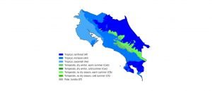
Many tropical areas experience only slight annual temperature variation, but very dramatic rainfall changes – often dividing their year into summer (dry season) and winter (wet season). Costa Rica is no exception, and the last few months of 2022 fully demonstrated the wrath of the ‘wet season’ – but all cannot be blamed on Tropical Storm Julia – because there is another culprit that snakes her soggy way around the globe, bringing storms, floods, mudslides and misery but also life-giving rains and reprieve to many areas around the tropical and sub-tropical world. This is the ITCZ, and with the wet season forecast to arrive in our Southern Pacific area between 23-26 of April 2023, this is a very fitting and timely post!


What is the ITCZ?
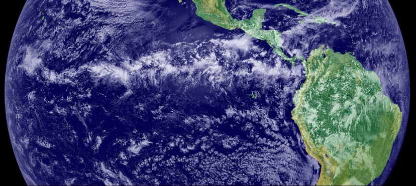
The Intertropical Convergence Zone is also known as Monsoon Trough, Near-Equatorial Trough, The Doldrums or The Calms. It is a band of clouds, rain and storms that encircles the entire globe – essentially it is a permanent trough of low pressure. The ITCZ forms over the hottest parts of the world, roughly in line with where the sun is directly overhead (but lagging in distance by 1-2 months due to lagging heating of the ocean).
The ITCZ is Not Always ‘Active’
Not the entire stretch of the Intertropical Convergence Zone is always ‘active’ – meaning showery or stormy. Large lengths of it may be dry due to factors such as dry air, variations in ocean water and air temperatures, local topography, or other conditions.

Names and Weather Charts
The ITCZ plays a vital role in weather forecasting for farmers, pilots, sailors, and tourism planners. Disaster managers also track it closely. For this reason, meteorologists highlight the ITCZ on weather charts. On April 24, 2023, the surface analysis map labels it as the “Monsoon Trof”, meaning: “Monsoon Trough.” This term marks areas of low sea-level pressure where the ITCZ is active. Depending on altitude and whether winds or pressure define the system, its charted location may vary. Where labeled, it signals an active area with rain, clouds, and storms. On this day, the ITCZ stretches across the Osa Peninsula and hugs the Costa Rica–Panama border.

Its Not All Its fault!!!
Not all rain comes from the Intertropical Convergence Zone. Daytime heating, sea breezes, and mountain lift spark local showers. Tropical storms, hurricanes, and low-pressure systems add to the mix. Fronts and other features also bring bursts of rain throughout the year. But when the ITCZ activates overhead, expect a serious pounding on the roof.
How does the ITCZ form?
Where land and ocean heat most intensely, the air rises and forms rain and storm clouds. Trade Winds rush in to fill the void, replacing the rising air and fueling more upward motion. These winds enter the ITCZ from the north and south, collide head-on, and push skyward. This creates a loop—air converges, lifts, and then returns to its origin. The cycle drives tropical weather and powers the pulse of global wind circulation.

Why is the ITCZ known as The Doldrums or The Calms when there are winds rushing into it?
The Trade Winds meet at the ITCZ and push upward. As they rise, the surface below turns calm and windless. This still zone is called The Doldrums—an old term from “dol,” meaning foolish or dull. Sailing ships trapped here must wait or drift until the winds return. This challenge has tested sailors for centuries.
On the weather chart, the Doldrums appear in blue and purple. Green, yellow, orange, and red show stronger winds. The calm zone stretches diagonally across the map, cutting through Costa Rica. Trade Winds converge into this quiet band from both sides. Off Costa Rica’s southwest coast, the windless area spans hundreds of kilometers—slow going for any sailboat.

How the ITCZ moves throughout the year
The Intertropical Convergence Zone forms over the hottest land and sea regions. These heat zones shift with the seasons. In July, the ITCZ hovers over Mexico, Central America, Colombia, and Venezuela. By January, it slides south over southern Colombia and northern Brazil. Land heats faster than water, so the ITCZ pulls farther north in July and farther south in January.

In Conclusion
Now you understand a global weather pattern that shapes life in Costa Rica. Right now, the ITCZ stretches across the country’s far southern edge. Next time someone complains about the rain—at a party or in line—speak up. Share a winding tale about the Intertropical Convergence Zone!
Just like most tropical and subtropical locations, our corner of Costa Rica is visited by tropical rain – it keeps the jungle lush and provides cooling relief during the hot afternoons, and it surely beats sub-freezing temperatures and blizzards! Come and experience the tropics – visit our RE/MAX WE SELL PARADISE website to view the hot properties in our local area.