Why So Few Tropical Storms and Hurricanes in Costa Rica?

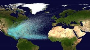
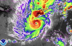
It is very interesting that the UK, Ireland, Norway, Iceland and even Greenland are hit by more tropical cyclones than Costa Rica (well, to be exact the post-tropical remnants of these tropical cyclones)! While Costa Rica is a tropical country and many of our northern neighbours are on edge during the annual hurricane season we are a bit of a special case, only suffering from two direct hurricane impacts in recorded history – and there is a very good reason behind this!
THE EQUATOR AREA IS VIRTUALLY TROPICAL CYCLONE – FREE
…and this includes Costa Rica. This is because hurricane formation needs six specific conditions to be met, and two of those are largely and permanently absent from our area. Several conditions fluctuate with seasons and with phenomena such as El Nino or La Nina, including Atmospheric Instability, High Humidity, Low level Atmospheric Disturbances and Wind Shear. These are the six conditions – the ones in black are present here while the ones in red are missing from our area:
- High Sea Surface Temperature of at least 26.5C or 80F
- Atmosphereic instability
- High Humidity
- Sufficient Coriolis Force (lack of this is what keeps the equator area clear of tropical cyclones)
- Exisitng low level atmospheric disturbance
- Low vertical wind shear (meaning winds that change rapidly with altitude)
Below is an explanation of the two missing conditions, the two reasons why we do not experience too many tropical disturbances here.
HIGH SEA SURFACE TEMPERATURE
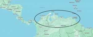
While the Sea Surface Temperatures around the Costa Rican coast are significantly warmer than 26.5C / 80F for most of the year, there is a catch – and this catch are the countries of Colombia and Venezuela. If the area was instead occupied by the ocean, Costa Rica would be in trouble as we would be facing oncoming hurricanes head-on as they strengthen over the hot waters of what would have been land. But thankfully, we have a shield in place!
In another defensive move, Colombia and Venezuela basically ‘block’ our area from existing storms, causing disturbances to curve northward (low pressure systems rotate counter-clockwise so when they hit land, they act as spinning wheels and deflect). The small pool of water between Costa Rica / Panama and Colombia is not sufficiently large to usually allow the formation of fully-fledged hurricanes (this has happened but is rare), though it can breed tropical storms and depressions with regularity.
CORIOLIS FORCE
THE SPIN
The Earth’s atmosphere spins at the same rate as the planet. At the equator, this speed is around 1,600 km/h or 1,000 mph. At the North and South Pole, the speed is essentially zero. The speed decreases between the equator and the poles. So a country like Colombia is spinning faster than Costa Rica, which itself it spinning faser than Mexico, North America or Europe.
THE AIRFLOW
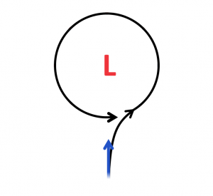
Now imagine air (wind) which flows northward from the equator, moving towards a low pressure area. It would be deflected more to the right the further north it moves, becaue it is entering the slower spinning atmosphere. It is travelling faster than the atmosphere it is entering. As a result, as it gets ahead of the low pressure area, it would then need to curve counter-clockwise towards the low pressure centre. This is why low pressure areas, including tropical storms, spin counter-clockwise in the northern hemisphere (and clockwise in the southern hemisphere). And this spin is needed for the formation of the hurricanes.
To think of it another way, imagine you are standing on the equator and throw the ball to your friend in Quepos. The ball will land to the right of your friend because, since you are spinning faster, the ball is travelling faster, to the right, than your friend is. The graphic below illustrates this – the blue arrow represents air moving from the equator area towards a low pressure system. Because the equatorial air is spinning faster, so it is moving to the right faster than the low pressure area, it gets ahead of the low pressure area and has to curve counter-clockwise to correct.
THE EQUATOR ENIGMA
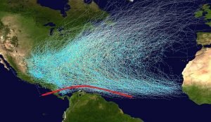
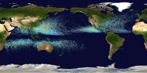
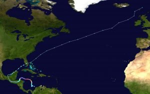
Spinning tropical systems generally cannot form within 5 degrees of the equator, and while Costa Rica lies between 8-11 degrees, the Coriolis Force is still fairly weak here, and as mentioned above we are not near a large enough area of hot water to facilitate frequent tropcial cycle development. While there has never been a recorded case of a tropical cyclone crossing or touching the equator, there have been instances of storms coming very close, within 160 kilometers or 100 miles.
SO WHY DO WE SOMETIMES GET HIT BY HURRICANES AND TROPICAL STORMS AND DEPRESSIONS?
Exceptions do occur, since the atmosphere remains fluid and unpredictable, with countless variables influencing storm behavior near the equator. Storms sometimes form between Costa Rica and Colombia, where tropical depressions, hurricanes, and cyclones have been recorded over the years. Steering currents occasionally push these systems southward, especially into northern Costa Rica, bringing unusual weather to equatorial regions. In such cases, a storm may drift closer to the equator, driven by its momentum and spin, even without strong Coriolis influence.
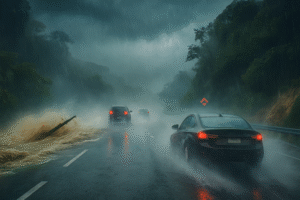
So Costa Rica is definitely within the firing line and has experienced devasating storms. While only suffering two direct hits from hurricanes in recorded history, Costa Rica still experiences occasional effects from the outer bands of tropical depressions, storms and hurricanes which may not directly pass over the nation, but which nevertheless send high winds, high waves and, especially, heavy rainfall our way.
Costa Rica has faced several major storms over the years, including Hurricane Eta and Tropical Depression 19 in 2020. Hurricane Nate struck in 2017, followed by Hurricane Otto in 2016 and Tropical Storm Alma in 2008. Earlier events include Hurricane Mitch in 1998, Hurricane Ceasar in 1996, Hurricane Gert in 1993, Hurricane Joan in 1988, and Hurricane Martha in 1969. Tropical cyclones most often impact Costa Rica during October and November, when seasonal conditions favor storm development and landfall.
WHY DOES COSTA RICA NOT GET HIT BY STORMS THAT FORM OFF OUR PACIFIC COAST?
This is because the steering currents, powered by great global air circulations, steer the storms towards the west. So any storm that forms off our Pacific coast generally moves to the north and west, avoiding making a landfall.
WHY SO FEW STORMS AROUND SOUTH AMERICA?
This is due to the cooler ocean waters due to global water currents and lack of disturbances from which hurricanes could form. And, especially, very unfavourable wind shear which is present in the area due to local weather conditions. It is extremely rare to see a hurricane form in South America except for the extreme northern Caribbean areas.
WHY ARE NORTHERN COUNTRIES SUCH AS ICELAND AND UK NOT AS DEVASTETED BY THE TROPICAL CYCLONES LIKE THE TROPCIAL COUNTRIES ARE?
There are a few reasons for this:
- By the time they get to the northern latitudes the storms are usually weaker with less precipitation and slower winds. Most have now transition to post-tropical cyclones, meaning they lost their organsiation and circulation.
- Tropical Cyclones are much ‘wetter’ in the tropics. This is because warmer air can hold more moisture and thus can dump much more rain.
- Tropical Cyclones are typically much slower-moving in the tropics. And so their devastating waves, winds and rain linger for much longer over an area.
- The infrastructure in tropical countries may not be as well developed. This includes drainage, slope engineering, roads and bridges, coastal defences etc. This magnifies the damage here vs countries like the UK or Ireland which are much better prepared.
- Construction standards may vary here, allowing homes and buildings to rise in risky zones. This include lands prone to flooding, landslides, or coastal wave damage. This magnifies the damage here.
DEFINITIONS
Lastly, we need to clear up a few definitions as the language around tropical weather can be confusing and location-dependent. There is often a lot of ambiuity in how forecasters, media and weather authorities use the definitions. Generally, these are a low pressure system in tropical or sub tropical areas with the following sustained wind speed characteristics:
- TROPICAL WAVE – a trough of low pressure which may develop into a more organsied Tropical Depression
- TROPICAL DEPRESSION – Under 63 km/h, or 39 mph
- TROPICAL STORM – 63 – 118 km/h or 39 – 73 mph
- TROPICAL CYCLONE – Over 118 km/h or 73 mph. Tropical cyclones go by several names depending on the region:
– Hurricane (Atlantic Ocean or NE Pacific Ocean)
– Typhoon (NW Pacific Ocean)
– Tropical Cyclone (Indian and South Pacific Oceans)
ADDITIONAL TERMS:
“Tropical Depression” can also be a term for a Tropical Storm and Tropical Cyclone.
“Tropical Low” can also be a term for a Tropical Storm and Tropical Cyclone.
“Tropical Disturbance” can refer to Tropical Depressions, Storms and Hurricanes.
“Tropical Storm” can also be a term for Hurricane.
“Tropical System” or “Tropical Disturbance” can refer to Tropical Depressions, Storms and Hurricanes.
“Low Pressure System” can refer to Tropical Depressions, Storms and Hurricanes.
Photos and graphics courtesy of Wikicommons.
Our wonderful tropical paradise has a trick up its sleave. We are virtually immune from the annual barrage of violent tropical weather! Although we still get the rain that keeps our forests lush and our animals happy! Costa Rica is the PERFECT location for your retirement, relocation, or vacation home. While you browse our local area listings, know that RE/MAX WE SELL PARADISE is your trusted real estate partner in amazing COSTA RICA!